Hurricane Dorian, still barreling towards South Florida, is expected to strengthen from a Category 2 to a Category 3 storm today (Aug. 30), according to the National Hurricane Center. It is even possible that the storm will further intensify to a Category 4, with winds reaching speeds of 140 mph (225 km/h), before hitting the mainland United States, CBS stated. The hurricane has so far forced the closure of NASA's Kennedy Space Center Visitor Complex for Sept. 1 and 2.
As the storm swells closer to land, satellites operated by NASA and the National Oceanic and Atmospheric Administration (NOAA) continue to track its movement and progress. You can see some of the images from those satellite observations below, which have been shared on social media.
Related: NASA Sees Hurricane Dorian from Space Station (Video)
August 30
On this #FullDiskFriday, both #GOESWest and #GOESEast are keeping a close eye on extremely dangerous #HurricaneDorian from 22,300 miles in space. #Dorian is now a Cat. 3 storm with maximum sustained winds of 115 mph, according to the @NHC_Atlantic. More: https://t.co/Uirlt2hAYA pic.twitter.com/R6Vmp5mOydAugust 30, 2019
Watch as the eye of #HurricaneDorian2019 begins to form in this 1-minute visible loop from NOAA's #GOESEast. "Dangerous Hurricane #Dorian poses a significant threat to #Florida and the northwestern #Bahamas," according to the @NHC_Atlantic. Latest: https://t.co/W7u6rft9x2 pic.twitter.com/AuDJst6smvAugust 30, 2019
In the last frame of this GeoColor loop from #GOESEast, which is from earlier on Friday morning, you can see that the eye of #Dorian was much less developed. pic.twitter.com/J0c6JPOvK6August 30, 2019
Major #HurricaneDorian, seen here by NOAA's #GOESWest, is now an extremely dangerous Cat. 3 storm. #Dorian is expected to strengthen and "poses a significant threat to #Florida and the northwestern #Bahamas," according to the @NHC_Atlantic. More: https://t.co/RCbt7BjzmA pic.twitter.com/3n0qIuZAvHAugust 30, 2019
Evening RT: Using satellite imagery from the @NASARain Constellation to diagnose the evolution of cloud and precipitation structure in Hurricane #Dorian >>https://t.co/j6ixdbrhpb pic.twitter.com/ApElVQ8UBmAugust 30, 2019
Cameras outside the space station captured these views of rapidly intensifying #HurricaneDorian at 12:18pm ET on August 30 as it churned over the Atlantic Ocean. For more on NASA’s coverage of #Dorian, visit: https://t.co/Si2ENfjBN0. pic.twitter.com/llcY8mXakwAugust 30, 2019
Take a look at all that lightning! The Geostationary Lightning Mapper aboard NOAA's #GOESEast captured this view of all the lightning associated with #HurricaneDorian2019 in the morning hours of Aug. 30, 2019. Follow the storm's path here: https://t.co/raWlm8629m pic.twitter.com/qxOMNmzXIqAugust 30, 2019
Hurricane #Dorian, seen here by NOAA's #GOESEast, is now a Cat. 2 storm with maximum sustained winds of 110 mph. A #HurricaneWatch is now in effect for the northwestern #Bahamas as the storm slowly churns across the western #Atlantic. More: https://t.co/BoZ5yx3P4K pic.twitter.com/I6WzHIg7EQAugust 30, 2019
📷 CloudSat shows a 3D animation of Dorian, still a tropical storm at the time, near Puerto Rico. CloudSat "slices" through clouds, enabling us to see their height, their different layers and the areas where the heavier bands of rain are found within the storm system. pic.twitter.com/ME7LKIl6GBAugust 30, 2019
Hurricane #Dorian, seen here by NOAA's #GOESEast, is now a Cat. 2 storm with maximum sustained winds of 110 mph. A #HurricaneWatch is now in effect for the northwestern #Bahamas as the storm slowly churns across the western #Atlantic. More: https://t.co/BoZ5yx3P4K pic.twitter.com/I6WzHIg7EQAugust 30, 2019
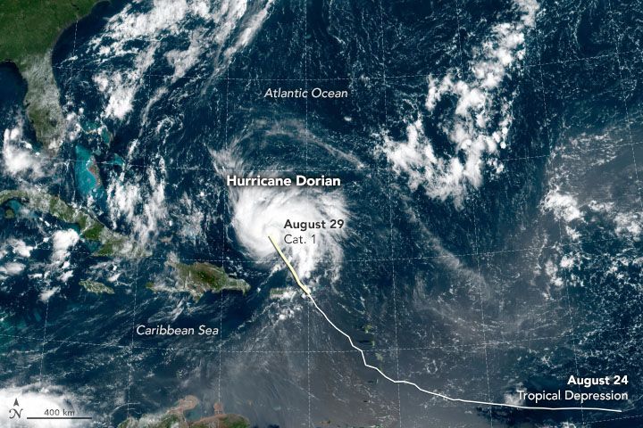
August 29
A camera outside the station captured views of Hurricane Dorian at 1:05pm ET today as it churned over the Atlantic Ocean north of Puerto Rico. pic.twitter.com/ZlfKPcuIQOAugust 29, 2019
NEW: This morning’s latest visible satellite animation from #GOES16 of #HurricaneDorian as it moves away from #PuertoRico and the #VI into the open waters of the Atlantic. Updates: @NHC_Atlantic pic.twitter.com/qtFJMofXjBAugust 29, 2019
August 28
This visible satellite animation from NOAA’s #GOES16 shows #TropicalStormDorian moving closer to the #VirginIslands and #PuertoRico this morning. Get the latest @NHC_Atlantic update here: https://t.co/oMuv0mLHtC pic.twitter.com/3sDHWXKo5tAugust 28, 2019
#GOESEast meso-sector is tracking #TropicalStormDorian. View 1-minute imagery of TS #Dorian via multiple #GOES16 bands HT @UW_AOS at https://t.co/cBL6ORMe5E pic.twitter.com/wmim7wgDl0August 28, 2019
Latest look at Hurricane #Dorian from @NOAA's GOES16. For official information stay tuned to @NHC_Atlantic and local @NWS WFOs. pic.twitter.com/ETzTUFWGfGAugust 28, 2019
Earlier this afternoon #Dorian strengthened to a Cat. 1 #hurricane with maximum sustained winds of 75 mph. NOAA's #GOESEast spotted the storm moving toward the #VirginIslands, where hurricane warnings are now in effect. Follow the storm's path here: https://t.co/55iomirKdi pic.twitter.com/8abVjNKTNpAugust 28, 2019
August 27
Tropical Storm #Dorian, seen in this view from NOAA's #GOESEast, moved over the Lesser Antilles this morning. While uncertainty remains high, the @NHC_Atlantic says wind and rain from this system could impact the Bahamas and Florida later this week. More: https://t.co/WkHwZm4dTn pic.twitter.com/PtXjEFZ8qIAugust 27, 2019
August 26
As #TropicalStorm #Dorian spins in the Atlantic, NOAA’s #GOES16 is keeping an eye on it. You can also see the #dust coming off the #SaharaDesert at the top right. Here’s the latest #tropical update: https://t.co/oMuv0mLHtC pic.twitter.com/JuZewn4P3ZAugust 26, 2019
UPDATE: The latest NOAA #GOES16 imagery shows #TropicalStorm #Dorian heading toward the #LeewardIslands. It is expected to strengthen while it moves into the #Caribbean on Tuesday. Here’s the latest: https://t.co/OT12jdyEoE pic.twitter.com/Xi8Ma6Mqx6August 26, 2019
Follow Chelsea Gohd on Twitter @chelsea_gohd. Follow us on Twitter @Spacedotcom and on Facebook.
Bagikan Berita Ini


0 Response to "Watch Hurricane Dorian in Action in these Gifs NASA and NOAA Took from Space - Space.com"
Post a Comment